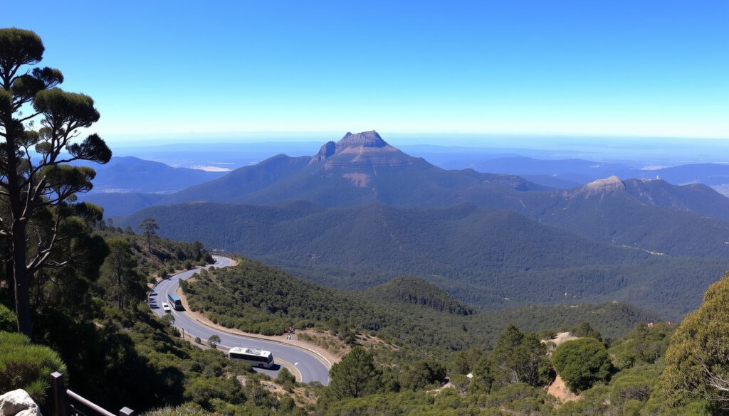
Mount Wellington (Kunanyi) Visitor Guide: Drive, Bus & Hikes
There’s a reason Kunanyi / Mount Wellington tops the Hobart to-do list: at 1,271 m (4,170 ft) it’s a short drive from the city centre, yet the air at the summit can feel a world apart. This guide pulls together the practical details—driving, bus, hiking, and safety—so you can plan a visit that matches the mountain’s unpredictable mood. All key facts come from the official park management authority Wellington Park and local government sources.
Elevation: 1,271 m (4,170 ft) ·
Location: Hobart, Tasmania, Australia ·
Drive time from Hobart: ~30 minutes (21 km) ·
Park area: Wellington Park ·
Last eruption: Permian period (over 250 million years ago) ·
Dual name: Kunanyi / Mount Wellington
Quick snapshot
- Sealed road (Pinnacle Road) leads to the summit (Wellington Park – getting there)
- No 4WD required for the drive (Discover Tasmania)
- Kunanyi is the original palawa kani name, adopted in 2013 (City of Hobart)
- Exact bus schedule can change seasonally — always check the Explorer Bus timetable
- Summit weather conditions can shift with minimal notice; alerts are posted on City of Hobart safety page
- Permian period: geological formation of sedimentary rocks (Wikipedia – Mount Wellington)
- Jurassic period: dolerite intrusion formed the Organ Pipes (Wikipedia – Mount Wellington)
- 2013: official dual naming to Kunanyi / Mount Wellington (City of Hobart)
- Check road gate status before departure (City of Hobart)
- Book the Kunanyi Explorer Bus for a guaranteed ride even in snow
Six key specs at a glance, one pattern: the mountain’s access is simpler than the weather makes it seem.
| Specification | Value |
|---|---|
| Elevation | 1,271 m (4,170 ft) |
| Drive time from Hobart | 30 min (21 km) |
| Bus service | Kunanyi Explorer |
| Entry fee | Free (parking fees may apply) |
| Gates open | Subject to weather, overnight stays not permitted |
| Dual name adopted | 2013 (Kunanyi / Mount Wellington) |
Can you drive up Mount Wellington?
Road conditions and vehicle requirements
Yes, a sealed road called Pinnacle Road runs from the suburb of Fern Tree all the way to the summit. The road is fully paved, so no 4WD is needed — any standard car can make the climb (Discover Tasmania (official tourism guide)).
However, the road can close without warning if snow, ice, or congestion make it unsafe. The Wellington Park management team posts real-time alerts on their website and via the Hobart City Council.
Parking at the summit
There is a small parking area at the top, but space is limited. On busy days, cars may be directed to park at The Springs and walk the last section. No overnight parking is permitted (City of Hobart safety guidelines).
Seasonal closures and weather alerts
Winter (June to September) brings the highest risk of snow closures. The summit can be 10 °C colder than Hobart, and wind speeds often exceed 80 km/h. Always check the City of Hobart mountain safety page before heading up.
The pattern is consistent across all official sources: the sealed road removes vehicle barriers, but weather decides whether you’ll actually use it.
How do I get to the top of Mount Wellington?
Driving directions from Hobart CBD
From Hobart’s city centre, take the A6 Huon Road south-west for about 10 minutes, then turn onto Pinnacle Road at Fern Tree. The full drive to the summit covers 21 km and takes roughly 30 minutes (Where Down Under travel guide).
Mount Wellington bus service (Kunanyi Explorer)
The Kunanyi / Mt Wellington Explorer Bus is the only licensed shuttle in Wellington Park. It departs from Brooke Street Pier in Hobart and takes about 50 minutes to reach the summit. The official timetable shows departures at 9:30 am, 11:00 am, 12:30 pm, 2:00 pm, and a 3:30 pm summer departure from October to April (Explorer Bus timetable).
The bus offers hop-on hop-off access at five stops up the mountain, and a 2.5-hour return tour includes 30 minutes at the summit. Crucially, the Explorer Bus is the only way to reach the summit when Pinnacle Road is closed due to snow (Klook activity listing).
Cycling and hiking alternatives
Many visitors cycle or hike up from Fern Tree. The most popular walking routes include the Organ Pipes Track (3 hours return), the Zig Zag Track (2 hours return), and the Pinnacle Track (4 hours return). Metro buses serve Fern Tree from Hobart, making it easy to start a hike (Where Down Under travel guide).
Drivers get flexibility but risk closure. Bus riders get reliability but fixed schedules. Hikers earn the view but need 2–4 hours and good fitness. Choose based on your tolerance for uncertainty.
What this means: each access method has a built-in vulnerability, and the most reliable option is also the least flexible.
Is it worth going to Mount Wellington?
Views and photo opportunities
On a clear day, the summit offers panoramic views of Hobart, the Derwent River, Bruny Island, and the Tasman Peninsula. The observation shelter (open 7 am–10 pm September to April, 7 am–5:30 pm May to August) provides a wind-protected spot for photos (Hobart and Beyond visitor guide).
Weather variability and best times
The summit can be 10 °C colder than Hobart, and snow is possible any month of the year, though most common from June to September (Where Down Under travel guide). The best viewing conditions are typically in the morning before clouds build up.
Cost and time investment
Entry to the mountain is free, though parking fees may apply at some lots. The drive takes only 30 minutes each way, making it a half-day activity. The Explorer Bus costs around $55 per adult return, which includes the guarantee of a summit visit even in snow.
The catch: the mountain’s biggest draw — those panoramic views — is also its most unreliable feature.
What is Mount Wellington famous for?
Geological significance (Organ Pipes dolerite columns)
The most striking feature is the Organ Pipes – a series of vertical dolerite columns formed during the Jurassic period when volcanic magma intruded into sedimentary rock. These columns are a major draw for climbers and photographers (Wikipedia – Mount Wellington).
Biodiversity in Wellington Park
Wellington Park protects over 18,000 hectares of alpine and subalpine ecosystems, home to rare endemic plants such as the mountain rocket and the cushion plant. The park is also a stronghold for the Tasmanian wedge-tailed eagle (Discover Tasmania biodiversity info).
Cultural importance to the Muwinina people
The mountain has been known as Kunanyi to the Muwinina people for thousands of years. In 2013, the Tasmanian government officially adopted the dual name Kunanyi / Mount Wellington to recognise this indigenous heritage (City of Hobart cultural page).
The dual name is more than symbolic. It connects the mountain’s geological story with the living culture of the Muwinina people, whose knowledge of the land is still passed down through the Tasmanian Aboriginal Community.
The implication: the mountain’s fame rests on three distinct layers — geology, ecology, and culture — and each adds a reason to visit beyond just the drive.
What can you do at Mount Wellington?
Hiking and walking trails
Wellington Park offers over 50 km of walking and mountain bike trails. The most popular routes start from The Springs: the Organ Pipes Track (3 hours return, moderate), the Pinnacle Track (4 hours return, challenging), and the Zig Zag Track (2 hours return, easy). The Wellington Park activities page provides a full trail map.
Mountain biking
The park has dedicated mountain bike trails, including the North-South Track and the Pipeline Track. Bikes are not permitted on all walking trails, so check the park’s activity zoning map before heading out.
Picnicking and lookouts
Key picnic spots include The Springs, The Chalet, and the summit area. Each has tables and toilets. The summit observation shelter provides a 360-degree view but can be crowded on weekends.
Guided tours and visitor activities
Several operators run guided tours, including the Kunanyi Explorer Bus with commentary, and private hiking tours. The Discover Tasmania website lists current tour operators and seasonal events.
With over 50 km of trails and activities for all fitness levels, the mountain is a full-day destination. Most visitors underestimate the time needed; plan for at least 4 hours to enjoy even a short walk and the summit views.
The pattern: activity options scale with time commitment, and the mountain rewards those who plan for more than a quick summit photo.
Pros and cons of visiting Mount Wellington
Upsides
- Free entry and easy drive from Hobart
- Panoramic summit views on clear days
- Diverse hiking trails for all levels
- Bus access even when road is closed
- Rich geological and cultural history
Downsides
- Weather can change rapidly, ruining views
- Road frequently closed in winter
- Limited summit parking on busy days
- Summit temperatures 10°C colder than city
- No overnight camping allowed
What this means: the same features that make Mount Wellington appealing — free access, proximity, variety — come with weather and crowding trade-offs that need advance planning.
How to plan your visit (step by step)
- Check the weather and road status – Visit the City of Hobart safety page for gate alerts and a live summit webcam.
- Choose your transport – Decide between driving, the Explorer Bus, or hiking. Book bus tickets in advance if you want a guaranteed summit.
- Pack layers and essentials – Bring a warm jacket, hat, water, and snacks. The summit is exposed and windy even in summer.
- Plan your activities – Download the Wellington Park trail map and decide which walks or lookouts to visit.
- Depart early – Morning trips offer the best chance of clear skies and less crowded parking.
- Respect the park – Stay on marked trails, take all rubbish home, and obey closure signs. The park is a protected area.
Quotes from the authorities
“Pinnacle Road can close due to snow, ice, or congestion. Drivers should check the road status before heading up.”
— City of Hobart (local government authority)
“The Explorer Bus is the only licensed operator able to take visitors up the mountain when the road is closed due to snow.”
— Wellington Park (park management)
“Weather on kunanyi / Mount Wellington is colder and more exposed than in Hobart city. Conditions can change quickly.”
— Discover Tasmania (official tourism guide)
“The summit observation shelter and toilets are open 7am to 10pm from September to April, and 7am to 5:30pm from May to August.”
The consistent message across all authorities: weather drives access, and access drives your experience.
For first-time visitors, the trade-off is clear: driving gives you flexibility but risks a closed gate. The bus guarantees a summit arrival but ties you to a schedule. The pattern across all expert sources is the same: check the weather first, then choose your transport.
Related reading: kunanyi / Mt Wellington Explorer Bus · Wellington Park – getting there
wellingtonpark.org.au, tripadvisor.com, tickadoo.com, bom.gov.au, abc.net.au
Frequently asked questions
Can you drive up Mount Wellington at night?
No, the Pinnacle Road gates are closed at night. The summit area is not open for overnight stays, and the road is locked from dusk to dawn. The exact closing time varies by season; check the City of Hobart safety page for current hours.
Are pets allowed on Mount Wellington walking tracks?
Dogs are not permitted on most walking tracks in Wellington Park to protect native wildlife. They are allowed on the main road and in the picnic areas at The Springs, but must be kept on a leash. Check the Wellington Park activities page for specific track rules.
Do you need chains for Mount Wellington in winter?
No, chains are not required because the road is sealed and cleared by park staff. However, if snow or ice is present, the road is typically closed rather than requiring chains. The City of Hobart advice is to drive only when the road is open and conditions are safe.
Is there a cafe at the top of Mount Wellington?
No, there is no cafe or restaurant at the summit. The nearest food and drink are available at The Springs kiosk (seasonal) and at the base in Fern Tree. Bring your own snacks and water, especially if hiking.
How cold is it at the summit of Mount Wellington?
On average, the summit is about 10 °C colder than Hobart city. In winter, temperatures often drop below freezing, and wind chill can make it feel much colder. Snow is possible any month, but most common June to September (Where Down Under guide).
What is the closest town to Mount Wellington?
The closest suburb is Fern Tree, about 10 km from Hobart’s CBD. Fern Tree is the starting point for Pinnacle Road and has a small general store, picnic area, and bus stop. The mountain is part of the Wellington Park, which lies within the City of Hobart municipal area.
Can you camp on Mount Wellington?
No, camping is not permitted anywhere in Wellington Park. The park is a day-use area only. The nearest campgrounds are in the Huon Valley or on the Tasman Peninsula. The summit gate closes at night, so you cannot stay overnight even in a vehicle.
Whatever your plan, the mountain rewards preparation. For the driver, the 30-minute climb is a short adventure that sets up a day of exploration. For the bus rider, the 50-minute journey comes with a guarantee of reaching the summit. For the hiker, the payoff is solitude and a deeper connection to the landscape. The choice is yours — but the weather will have the final say.
More related posts
 Chris Scott AFL Coach: Biography, Record, and Net Worth
 Vasco da Gama: Life, Voyages & Legacy of Portuguese Explorer
 Bryce James: Height, NBA Prospects, and Redshirt Path
 Connie Angland: Biography, Career, and Family Life
 Dark Humor Jokes: Your Guide to Morbidly Funny Laughs
 David Hockney: Life, Art, Partner, and the Death Hoax Explained
 Stark Varg Australia – Price, Specs, Dealers & Availability
 Stuart MacGill: Kidnapping, Cricket Career, and Court Case